The Gulf of Maine is an international watershed in the North Atlantic stretching north from Provincetown at the tip of Massachusetts Bay in the Commonwealth of Massachusetts to Cape Sable on the Bay of Fundy in the province of Nova Scotia in Canada. For over 13,000 years, the Gulf has been developed around access to the coast for fishing, trading, and recreation. Today, these coastal development patterns put the cultural landscapes, economies, communities, and aging infrastructure systems along the Gulf at risk.
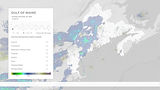
Climate Futures on the Gulf of Maine uses place-based scenario planning to illustrate the risks, vulnerabilities, and plausible futures for ten infrastructure systems along the rim of the Gulf. Place-based scenario planning is a method of long-term strategic planning that creates representations of multiple, plausible futures that are used to inform decision-making in the present. While complementary to probabilistic models used to forecast future vulnerabilities, scenario-based planning shifts emphasis from statistical probability to ways of thinking about the future. The goal of place-based scenario planning is not to predict the most likely outcome, but to reveal biases and blind spots in complex and non-linear situations.
Climate Futures uses the medium of landscape representation to surface the cultural value systems embedded in existing infrastructural systems, and position landscape as a driver when evaluating design from individual infrastructures to the Gulf of Maine watershed.
At Provincetown Municipal Airport, the Hatches Harbor dike is overtopped, sending storm surge racing through the marsh and over the tarmac at the airport. Flights from Provincetown Municipal are grounded indefinitely. Simultaneously, Route 6, the Cape’s primary evacuation route, is flooded to the south in Wellfleet, cutting off emergency services to the Outer Cape by road and air early during the nor’easter.

Provincetown Municipal Airport during the Storm of the Century 2030.
.jpg)
Scenario 0
STORM OF THE CENTURY 2030
The Storm of the Century 2030 projects an early season nor’easter that undergoes explosive cyclogenesis, also known as bombogenesis, and rapidly intensifies over Thanksgiving week in 2030. The scenario investigates the vulnerabilities in existing aging infrastructure systems across the Gulf of Maine and describes the potential costs of doing nothing.
The storm arrives on the Gulf of Maine the week before Thanksgiving in 2030. The drop in barometric pressure, freezing temperatures, and storm surge over an astronomical tide overwhelm and flood the Gulf’s low-lying infrastructure systems.
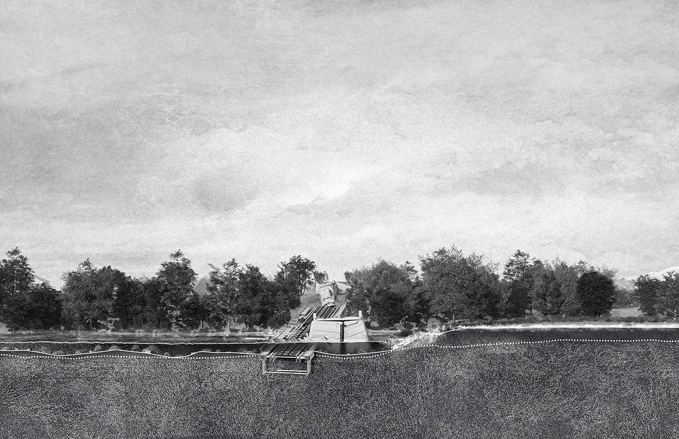
The temporary bridge over the Machias and Middle Rivers collapses when storm surge rushes up the Machias River, damages the tidal gates, and washes out the causeway. Recovery efforts are overwhelmed by flooding throughout downtown Machias, including at the nearby wastewater treatment plant.

US-Route 1 Dike Bridge #2246 during the Storm of the Century 2030.

The banks of the Salmon River are saturated and collapse the Via Railway track, plunging the railway into the river. No one is injured, but the track collapse pauses passenger train service east of Truro indefinitely.
Salmon River Railway Bridge during the Storm of the Century 2030.

While the salt marsh around the Seabrook Station Nuclear Power Plant buffer the campus from storm surge during the storm, an alkali-silica reaction (ASR) occurs in the concrete seawall surrounding the plant, causing cracking. The low-lying roads flooding the plant make it impossible for emergency crews to reach the campus, leaving the on-site crew to stay awake without backup throughout the duration of the storm.

Seabrook Station Nuclear Power Plant during the Storm of the Century 2030.

Early during the storm, heavy precipitation overwhelms Saco’s sewage system, discharging wastewater through its combined sewer overflow (CSO) outfalls. The Saco River overflows its banks, flooding the Water Treatment Plant with sewage. The cleaning process takes a week, during which time residents live with a boil water advisory.

Saco Water Treatment Plant during the Storm of the Century 2030.

After power goes out at the Gloucester Wastewater Treatment Plant, the facilities manager fails to complete the emergency generator’s on-site manual startup. Electrical equipment is submerged in corrosive seawater while effluent and solid waste spills out into the Annisquam River, leaving the City without wastewater treatment for two weeks before repairs are completed. Shellfishing grounds are permanently closed after the storm.

Gloucester Wastewater Treatment Plant during the Storm of the Century 2030.

The electric and broadband cables running along the seafloor from Stonington to Isle au Haut snap during the storm, leaving residents without electricity or internet. The Isle au Haut Electric Power Company begins to clear debris and cut trees from the proposed microgrid site, expecting that the panels will be fully operational in six months.

Isle au Haut Microgrid site during the Storm of the Century 2030.

The causeway to Sears Island calves and falls into the surrounding Long Cove. Vehicular access is not restored, and the island is only accessible to pedestrians at low tide, or by boat.

Sears Island during the Storm of the Century 2030.

All emergency services and access to Yarmouth Regional Hospital are suspended after waves surge over the Hospital’s helipad and the main access road. Emergency generators are activated as well as temporary pumps after saltwater intrudes into municipal water and sewer pipes.

Yarmouth Regional Hospital during the Storm of the Century 2030.

The first floor of the Lubec Consolidated School is flooded by storm surge that overtops the saturated ground after an unusually wet autumn. In the aftermath of the storm, trailers are set up for students, who cannot return to the building due to mold found growing in the water-logged basement.

Lubec Community School during the Storm of the Century 2030.
